Professional location map builder

Design personalized location maps for free using readily adaptable templates and symbols.

banner banner

Why EdrawMax creat your location map?

Simple Customization
Simple customization craft maps by changing styles of lines and shapes at will with the user-friendly interface. Drag and drop elements from the symbols offered by EdrawMax to display vast areas for precise element representation.
Visio & More Supported
Enhance collaboration by utilizing collaborative group folders for document sharing and contribution among EdrawMax users. Effortlessly export and smooth sharing your location maps in multiple formats, accommodating various devices such as VSDX, JPG, PNG, PPT, PDF, Docx, SVG, and others."
Seamless Teamwork
Cloud-Based Workspace for Smooth Collaboration . In addition, yon can give permission to your team and other stakeholders for them to view and edit your files. Collaborate effortlessly with EdrawMax, simplifying your diagramming workflow.

Location map software for everyone.

banner
Travel and Tourism Industry
It helps them highlightattractions, hotels, restaurants, and other points of interest.
banner
Researchers and Academics
It helps them understand patterns, relationships, and trends invarious fields such as geography, environmental science, and social sciences.
banner
Non-profit Organizations
It helps them visualize the impact oftheir initiatives and target their efforts where they are most needed.

More EdrawMax features.

banner
Seamless Teamwork
EdrawMax facilitates real-time collaboration, allowing team members to work together on diagrams and share feedback instantly, fostering teamwork, and accelerating project progress.
banner
Enhanced Efficency
With its intuitive interface, pre-made templates, and extensive symbol libraries, EdrawMax enables teams to create professional-quality diagrams quickly, saving time, reducing effort, and increasing productivity.
banner
All in One
EdrawMax allows for making 280+ types of diagrams including flowcharts, mind mapps, Gantt charts, timelines and more, streamlining workflows and eliminating the need for multiple software, enhancing convenience.
banner
Improved Communication
Use visually compelling diagrams to convey complex ideas, facilitating clear and concise communication within teams and with stakeholders, boosting understanding and decision-making processes.
What is
Location map

A location map is a visual representation of a specific area or region that shows the geographical location of various points of interest, landmarks, oraddresses. It provides a graphical overview of the spatial relationships between different locations and helps users understand the relative positionsand distances between them.

A location map typically includes features such as roads, highways, bodies of water, and other geographical features. Itmay also include symbols, markers, or labels to represent specific points of interest, such as cities, landmarks, businesses, or addresses.

Locationmaps are commonly used for various purposes, including navigation, travel planning, real estate, urban planning, marketing, and emergency response. Theyprovide a visual reference that helps users orient themselves, find directions, and understand the spatial context of a particular area.

With the advancementof technology, location maps can be created and accessed through various mediums, including paper maps, online mapping platforms, mobile applications,and GPS devices. These maps can be customized, interactive, and integrated with additional data layers or information to enhance their functionalityand usefulness.

Benefits of
location map

Location maps offer several benefits across different contexts and industries. Here are some key benefits of using location maps:

Spatial Visualization: Location maps provide a visual representation of geographic data, allowing users to easily understand and interpret spatial relationships. They helpin visualizing patterns, distributions, and connections that may not be apparent in tabular or textual data.

Navigation and Wayfinding: Location mapsassist in navigation and wayfinding by providing a clear overview of an area and helping users determine the best routes and directions to reach theirdesired destinations. They can include markers, labels, and symbols to represent specific locations or landmarks, making it easier for users to find theirway.

Communication and Collaboration: Location maps serve as a common visual language that facilitates communication and collaboration among stakeholders. They provide a shared understanding of geographic information, making it easier to convey ideas, present findings, and engage in discussions.

Overall, location maps provide a powerfultool for visualizing, analyzing, and communicating geographic information. They enhance decision making, improve efficiency, and support a wide rangeof applications across industries and sectors.

History of
Location map

The history of location maps dates back to ancient times when humans began creating visual representations of their surroundings. Here is a brief overviewof the history of location maps: In the 2nd century AD, the Greek geographer Claudius Ptolemy created a series of maps that were based on a grid system and included latitude and longitude lines. These mapswere influential in the development of cartography. The 16th and 17th centuries saw a cartographic revolution with the development of more accurate and detailed maps. Prominent cartographers like Gerardus Mercator and Abraham Ortelius made significantcontributions to mapmaking during this period. The 18th and 19th centuries witnessed further advancements in cartography. Theuse of triangulation, accurate surveying techniques, and the development of contour lines improved the accuracy and detail of maps. The rise of the internet and web-based technologies in the late 20thcentury and early 21st century led to the development of online mapping platforms. Companies like Google introduced online mapping services, making mapsaccessible to a wide audience.

Today, location maps continue to evolve with advancements in technology. Interactive maps, satellite imagery, and real-time data integration have become common features in modern mapping applications.

Types of Location map.

City Subway Map
Directional Map for School
City Drecitional Map

How to create a location map?

  • Clarify the purpose ofyour location map and collect accurate data for your location map. This may include addresses, coordinates, landmarks, or any other relevant information.
  • Select a mapping tool or software thatsuits like Google Maps or Mapbox to desktop GIS software which is user-friendly and provides the features you require.
  • Customize the appearance of your map to make it visually appealing and informative. Choose a suitable base map, adjust colors and styles, and addlabels or symbols to represent locations or features. Consider using different colors or symbols to differentiate between different categories or typesof locations.
  • Test your location map to ensure that it functions correctly and displays the desired information accurately. Review the map forany errors, inconsistencies, or missing information. Make any necessary adjustments or corrections.

What our customers say.

Vijay Kumar, Business Leader
EdrawMax has proven to be an invaluable asset in my pursuit of creating accurate and complex location map. The rich repository of symbols and templates allowed my team and I to construct comprehensive diagrams with ease.
Jagdish Chandra, Logistics Managers
Having extensively utilized EdrawMax for the creation of location map, I am compelled to talk about its efficacy. We used MS Visio for a very long time, but when we moved to EdrawMax, we didn't even renew our Visio license.
Ashwin S, Outdoor Enthusiasts
With EdrawMax's intuitive interface and free templates, I confidently recommend it as one of the best software for professionals and new interns.

FAQs about location map.
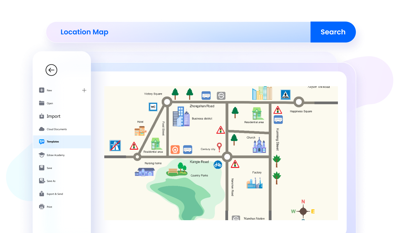
  • You can create various maps, including travel itineraries, business locations, event venues, hiking trails, real estate listings, and more. With its user-friendly and customizable features, you can design maps that cater to your specific goals, making navigation, planning, and visualization effortless.
  • Yes, EdrawMax's Location Map Maker offers a variety of pre-designed templates to choose from. These templates cover different location maps, such as travel itineraries, business locations, event venues, and more. These templates can help you start quickly and provide a foundation for your map.
  • Yes, absolutely! EdrawMax's Location Map Maker allows you to fully customize your maps. You can modify colors, styles, text, icons, and more. You can also add your own locations, routes, and labels to tailor the map to your specific needs.
  • Yes, EdrawMax's Location Map Maker supports collaboration. You can invite your team or colleagues to collaborate on a map in real-time. This feature is perfect for projects requiring multiple people's input and contributions. To invite your team, click the share button in your screen's upper right-hand corner.
  • Yes, EdrawMax's Location Map Maker includes Edraw AI, which simplifies and optimizes the creation and optimization of diagrams and text. With a single command, it can generate flowcharts, mind maps, optimize diagram layout and style, and extract text from images using OCR.